 European Green Belt
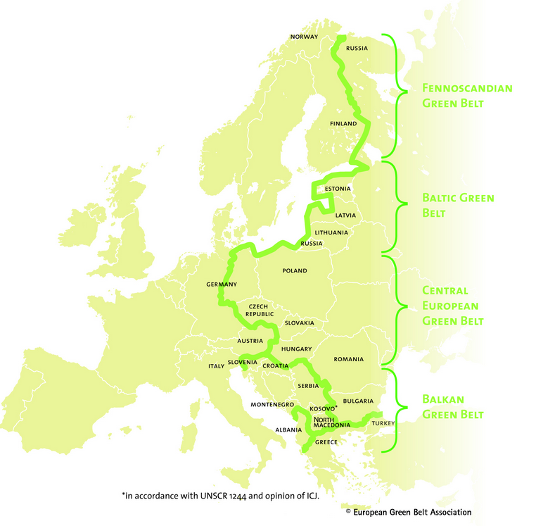
For nearly 40 years, the Iron Curtain that divided Western and Eastern Europe created a unique ecological network and a distinctive memorial landscape. Despite the occupation, the border zone stretching over 12,500 kilometers from the Barents Sea to the Black Sea provided exceptional conditions for nature to thrive. Quite by accident, the divided Europe contributed to the protection of nature and the preservation of valuable species. The border area became a unique refuge for endangered plants and animals. As early as the 1970s, environmentalists noticed the flourishing of undisturbed wildlife in certain parts of Europe.
The “European Green Belt” project, launched in 2003, emerged as a union of various regional initiatives into a unified European movement. Today, the “Green Belt” connects 24 countries and forms the backbone of Europe’s ecological network, playing a significant role in the development of Europe’s Green Infrastructure. The “Green Belt” is a symbol of international cooperation and the preservation of Europe’s natural and cultural heritage. The ecological corridor along the European Green Belt consists of 40 national parks. More than 3,200 protected areas are located within this 50-kilometer buffer zone, which spans nearly all European biogeographic regions.
Baltic Green Belt – The Coastal Strip
The “Baltic Green Belt” stretches along the coast of the Baltic Sea. This part of the European Green Belt is unique due to its marine biodiversity and highly varied coastline, featuring large sand dunes, wide beaches, striking cliffs, and unique lagoons. Former Soviet military zones acted as natural sanctuaries for millions of migratory birds and many marine animals (such as grey and ringed seals). However, since the early 1990s, the region has come under increasing pressure due to regional development. One of the main challenges of the “Baltic Green Belt” initiative is to preserve the natural and historical treasures of this beautiful and popular landscape.
Lithuania’s Green Belt – Three Coastal Gems
In Lithuania, the Green Belt encompasses a 98 km stretch of sandy coastline and includes the Seaside Regional Park, the Curonian Spit, and the Nemunas Delta Regional Park. The narrow Curonian Spit, located between the Curonian Lagoon and the Baltic Sea, is made up of sand brought by water currents and is considered the most valuable coastal landscape complex in Lithuania, featuring a dune ridge unique in Europe. The spit also serves as a migratory route for birds. The Nemunas Delta Park is a maze of islands, branches of the river, flood meadows, coastal marshes, and forests, making it an ideal habitat for migratory birds. The coast of the Seaside Regional Park is characterized by wide beaches, which in some places are replaced by bluffs with falling trees.
This project is implemented with the financial support from the BESTbelt project of the European Union. The contents of this project are the sole responsibility of Lithuanian countryside tourism association and can under no circumstances be regarded as reflecting the position of the European Union.